Iyo (Temples 39-65)
Enkō-ji (Temple 39) to Sankaku-ji (Temple 65) · the third of the four dōjō
Part of the Shikoku 88 Temple Pilgrimage.
Iyo is the third of the four dōjō: 365.7 km from Enkō-ji, Temple 39, to Sankaku-ji, Temple 65, with 26 of the 88 temples on it — more than any other section. It carries every spacing the circuit has. The step from Temple 43 to Temple 44 measures 70.4 km on the walked line, the widest in this section; the run from Temple 46 to Temple 51 puts five steps under 5 km each.
The fourteen day stages below were cut from the walked line by a rule rather than copied from a guidebook, so anyone with the files can re-run them and get the same days.
Key Facts
| Distance | 365.7 km (this section's own walked line through its 26 pinned relations; their member ways sum to 366.7 km, and the four dōjō together to 1,140.9 km) |
|---|---|
| Typical duration | 14 days (range 10–19) |
| Topology | Linear |
| Difficulty | Hard |
| Countries | Japan |
| Elevation range | 0–800 m (total ascent 6,030 m, descent 5,760 m) |
| Start | Enkō-ji, Temple 39 |
| End | Sankaku-ji, Temple 65 |
The typical duration is a pace estimate, not a stage count: it divides this section's 365.7 km by the pace the pilgrimage's own declared figures imply, about 26.7 km a day. The day cut below divides the same line 14 ways.
Elevation Profile
Ascent, descent and every high and low point on this page are sampled from the SRTM 30 m digital elevation model at each of the walked line's 13,983 vertices, with a 20 m threshold so the model's own noise is not counted as climbing. This section carried none of it until now: the line is two-dimensional, and the figures come from the model rather than from the geometry. Read them as this line's, not the henro trail's in general — where the pinned relations follow a road, the model reads the road.
The files also hold point heights on temples, where OpenStreetMap tagged one. Eighteen of the 88 temple waypoints carry one — three in Awa, three in Tosa, five in Iyo and seven in Sanuki. Iyo's five are Iwaya-ji (Temple 45) at 560 m, Senyū-ji (Temple 58) at 250 m, Yokomine-ji (Temple 60) at 750 m, Maegami-ji (Temple 64) at 250 m and Sankaku-ji (Temple 65) at 350 m, and they are what the sampling can be checked against: the model reads 754 m where the line passes Yokomine-ji and 255 m at Senyū-ji. Maegami-ji is the one wide disagreement — 48 m read where the line passes 59 m from a temple the map puts at 250 m — and that is a fact about where the line goes, not about the model. A height at a gate is still not a profile between gates, and nothing here interpolates one — the profile above is read off the line itself.
Sankaku-ji closes this section at 340 m and opens Sanuki at 350 m. The two sections cut their own lines at different vertices near the one temple, which the map itself puts at 350 m, and each figure is the reading on the line it belongs to.
Stages
| # | Stage | Distance | Ascent | Descent | Hours | How the day ends |
|---|---|---|---|---|---|---|
| 1 | Enkō-ji (Temple 39) → Kanjizai-ji (Temple 40) | 27.2 km | 460 m | 490 m | 6–9 | Temple |
| 2 | Kanjizai-ji (Temple 40) → Hotel Ailin | 26.6 km | 550 m | 550 m | 6–9 | Lodging |
| 3 | Hotel Ailin → Butsumoku-ji (Temple 42) | 26.1 km | 440 m | 260 m | 6–8 | Temple |
| 4 | Butsumoku-ji (Temple 42) → Ozu | 32.5 km | 660 m | 830 m | 8–11 | Town |
| 5 | Ozu → Rairakuku | 26.5 km | 370 m | 270 m | 6–8 | Lodging |
| 6 | Rairakuku → Karibaen | 26.1 km | 980 m | 550 m | 7–9 | Lodging |
| 7 | Karibaen → Ichiriki | 17.5 km | 490 m | 540 m | 4–6 | Lodging |
| 8 | Ichiriki → Ishite-ji (Temple 51) | 27.9 km | 240 m | 680 m | 6–8 | Temple |
| 9 | Ishite-ji (Temple 51) → Hōjō Suigun Youth Hostel | 24 km | 90 m | 150 m | 5–7 | Lodging |
| 10 | Hōjō Suigun Youth Hostel → Nankobo (Temple 55) | 28.3 km | 110 m | 110 m | 6–8 | Temple |
| 11 | Nankobo (Temple 55) → ゲストハウス BEKKU | 31.6 km | 290 m | 280 m | 7–10 | Lodging |
| 12 | ゲストハウス BEKKU → Maegami-ji (Temple 64) | 25.7 km | 880 m | 870 m | 7–9 | Temple |
| 13 | Maegami-ji (Temple 64) → HOTEL AZ 愛媛土居インター店 | 32.8 km | 150 m | 180 m | 7–10 | Lodging |
| 14 | HOTEL AZ 愛媛土居インター店 → Sankaku-ji (Temple 65) | 13 km | 320 m | 0 m | 3–4 | Temple — section boundary |
A day ends at a temple whenever one falls between 25 and 30 km along the walked line; where none does, it ends at the nearest named accommodation or town waypoint on the line instead, and a day that comes within 30 km of the section's own end anchor ends there whatever its length. Six of Iyo's fourteen days end at a temple, seven at a lodging and one at a town. Every distance is the length of route.main.geojson between that day's own two anchors, and every anchor carries a note in stages.json saying which arm of the rule chose it; the whole rule, its tie-breaks and the readings it refuses are written out in metadata.json's provenance.
The last day is the shortest of the forty the four dōjō were cut into, and it is short for one reason: a day that comes within 30 km of the section's end anchor ends at that anchor whatever its length. Sankaku-ji closes Iyo, and Sanuki starts from the same point.
The hours are derived, not reported. Each is Naismith's rule read at two paces and rounded to whole hours — five kilometres an hour plus 600 m of ascent at the fast end, 3.5 km/h plus 500 m at the slow — with no roughness factor, because this dataset holds no walking times for the henro trail to fit one against. Read a window as what a day's distance and climbing cost rather than as a day anyone walks in one go. The widest window here belongs to the 32.8 km thirteenth day, at 7–10 hours. metadata.json's hoursNote gives the rule and what it was checked against.
Interior Journey
The narrative and reflection prompt for each stage below are editorial writing, grounded only in what the stage contains — its temples, shrines, towns, spacing and distance. All 14 were read against that evidence and cleared by a reviewer who did not write them, then edited for readability; the edited wording is awaiting a second reading. See docs/review/shikoku-88.md for the checks stage by stage, and docs/data-sources.md for what is, and isn't, independently sourced.
Stage 1 Enkō-ji (Temple 39) → Kanjizai-ji (Temple 40)
Enkō-ji to Kanjizai-ji is 27.2 km, and this day is the whole of that step: a gate at each end and none between. Twenty-three bus stops stand on it. Sukumo comes at 6.8 km and Ainan at 26.8, and the twenty kilometres between them hold no town at all. At 13.1 km, in the middle of that, stands the only viewpoint mapped anywhere in Iyo, and nothing is mapped in the 5.2 km before it — the longest such stretch on the day. Kanjizai-ji closes it.
One viewpoint in nine hundred and fifty-three places, and the 5.2 km before it hold nothing at all — what were you looking at on the way there?
Stage 2 Kanjizai-ji (Temple 40) → Hotel Ailin
Kanjizai-ji to Ryūkō-ji is 49.7 km, the second-widest step between two temples in Iyo, and this day walks the first 26.7 of it — the next gate is still 23.0 km beyond where it stops. Thirty-five places are mapped on the way, twenty-four of them bus stops, and shops, hospitals, places to eat and a pharmacy are nearly all the rest. Nothing between its ends is a shrine, a town or a viewpoint, which is true of only one other day here. And nothing at all is mapped for 9.7 km, the longest such stretch anywhere in this section. The day ends at Hotel Ailin.
The longest stretch in the section with nothing mapped falls in the middle of this day. Who decided what was worth mapping?
Stage 3 Hotel Ailin → Butsumoku-ji (Temple 42)
More places stand on this day than on any other in Iyo — sixty-two bus stops among them, and eighteen places to eat. Much of it arrives at once: six of the section's places to stay stand inside 1.5 km of each other, the Uwajima station among them, and, just before them, the only ruins mapped in Iyo. Then it thins, and both of the day's temples fall in its last 3.1 km — Ryūkō-ji, 49.7 km on from Kanjizai-ji, and Butsumoku-ji, where the day ends.
The busiest day in the section, and both its gates stand in the last three kilometres of it. Which part will you have been walking for?
Stage 4 Butsumoku-ji (Temple 42) → Ozu
Meiseki-ji stands 10.9 km into this day and is the only temple on it. Just past it the map does something it does nowhere else in Iyo: twenty-eight numbered wayside shrines of a single series inside 1.7 km — more than half of all the wayside shrines mapped in the section. Seiyo comes in the middle of them. After that the day runs 20.0 km to Ozu and stops there. Meiseki-ji to Daihō-ji is 70.4 km, the widest step between two temples in Iyo, and 48.9 km of it are still ahead.
Twenty-eight numbered shrines inside 1.7 km, and one temple in 32.5 — which of those two counts is the day?
Stage 5 Ozu → Rairakuku
This is the only one of Iyo's days with no temple anywhere on it — none at either end and none between. It sits inside the 70.4 km from Meiseki-ji to Daihō-ji, the widest step between two temples in the section, and when it stops there are 22.4 km of that step still to walk. Most of what is mapped on it is bus stops. Three stations come inside 3.7 km — Niiya, Kitayama and Ikazaki — and the town of Uchiko after them. It ends at Rairakuku, a guesthouse.
A whole day inside the gap between two gates, with neither of them on it. Does walking need a destination, or only a direction?
Stage 6 Rairakuku → Karibaen
Daihō-ji stands 22.4 km into this day and closes the 70.4 km that have run since Meiseki-ji. Before it the map almost gives out: 8.8 km with nothing mapped on them, the third-longest such run in Iyo. Six places to stay stand on the day — three of them inside its last 700 m — and seven public toilets. Karibaen, the last of the beds, ends the day.
Twenty-two kilometres to one gate, then three beds inside seven hundred metres. The day's shape is all at its ends — where does its middle go?
Stage 7 Karibaen → Ichiriki
Sixteen places are mapped on this day, the fewest of any day here, and twelve of them are bus stops. Iwaya-ji comes 6.4 km in, 10.2 km on from Daihō-ji; the map gives it a height of 560 m, one of five heights it gives any temple in Iyo. Past the temple nothing is mapped for 9.6 km, the second-longest such run here. Then the town of Kumakogen, and just past it the guesthouse where the day ends — the shortest Iyo has cut but one.
Sixteen places mapped in 17.4 km, and nine and a half of those kilometres hold none of them. Is a day like that short, or long?
Stage 8 Ichiriki → Ishite-ji (Temple 51)
The day walks 14.7 km before it reaches a temple, and then six come inside 13.2 km. Jōruri-ji first, Yasaka-ji 0.9 km after it — the narrowest step between two temples anywhere in Iyo — then Sairin-ji, Jōdo-ji, Hanta-ji, and Ishite-ji closing the day. Each of the five steps between them is under 5 km, and this is the only run of five in the section of which that is true. Most of what reaches the day is bus stops.
Six gates in one day, the closest pair 0.9 km apart. Does arriving get easier with repetition, or thinner?
Stage 9 Ishite-ji (Temple 51) → Hōjō Suigun Youth Hostel
Twelve of Iyo's forty-one places to stay stand inside 800 m of each other, beginning 0.8 km into this day — nowhere else in the section are beds mapped so close together. After them the day runs to a railway: Taisan-ji, Enmyō-ji 2.6 km on, and then five stations inside 8.4 km — Iyo-Wake, Horie, Kōyōdai, Awai and Yanagihara.
Twelve places to stay inside eight hundred metres, all of them in the day's first 1.7 km. What does it do to a morning to pass every bed you could have slept in?
Stage 10 Hōjō Suigun Youth Hostel → Nankobo (Temple 55)
Enmyō-ji is 34.9 km behind before a temple appears again — the fourth-widest step between two temples in Iyo — and this day walks 24.7 km of that gap before Enmei-ji stands. Nankōbō comes 3.6 km after it and closes the day, so both of the day's gates fall inside its last 3.6 km. Most of what is mapped on it is bus stops; four of the rest are stations — Asanami, Kikuma, Iyo-Kameoka and Ōnishi.
Twenty-five kilometres, and then two gates inside four. Does the waiting belong to the arriving, or is it its own thing?
Stage 11 Nankobo (Temple 55) → ゲストハウス BEKKU
Nankōbō opens this day and four more temples follow inside 14.7 km — Taisan-ji 3.1 km on, Eifuku-ji 3.0 km after that, Senyū-ji 2.4 km after that, and Iyo Kokubun-ji. Then nothing: Yokomine-ji, the next temple, is 27.7 km on from Iyo Kokubun-ji, and the day walks 17.0 km of that before it stops. Imabari stands 0.2 km into the day, the last town mapped in Iyo. Forty-one bus stops stand on it.
Five gates in the first fifteen kilometres and none in the last seventeen. Which half of the day will you remember having walked?
Stage 12 ゲストハウス BEKKU → Maegami-ji (Temple 64)
Yokomine-ji stands 10.8 km into this day, 27.7 km on from Iyo Kokubun-ji, and the map gives it a height of 750 m, the highest of the five it gives any temple in Iyo. Little stands near it: across 14.5 km only the temple and three public toilets are mapped. Then the spacing closes — Kōon-ji, Hōju-ji, Kichijō-ji and Maegami-ji, four temples inside 6.2 km with two stations and a guesthouse among them.
One gate with fourteen kilometres of almost nothing around it, then four inside six. Does a temple mean more when it is the only thing there?
Stage 13 Maegami-ji (Temple 64) → HOTEL AZ 愛媛土居インター店
Iyo's longest day, 32.8 km, and between Maegami-ji and the hotel it ends at, nothing is mapped as a place to stay. No temple stands on it either: Maegami-ji to Sankaku-ji is 45.8 km, the third-widest step between two temples in the section. Most of what is mapped on it is bus stops. Six sacred places, four hospitals and four convenience stores are most of what is left, and one station, Iyo-Doi, comes 4.0 km before the end.
The longest day in the section, and no bed mapped between its ends. How far do you trust a map to know where you can stop?
Stage 14 HOTEL AZ 愛媛土居インター店 → Sankaku-ji (Temple 65)
13.1 km, the shortest day in Iyo, and it is short for one reason: a boundary day ends at the boundary temple whatever its length. Eighteen places are mapped on it — shops, bus stops, toilets, a restaurant, and the station at Iyo-Sangawa 2.8 km in. Nothing between the hotel it starts from and the temple it ends at is a shrine, a town or a viewpoint; only one other day in the section is like that. Maegami-ji to Sankaku-ji is 45.8 km and this day is its last 13.1. Sankaku-ji closes Iyo, and Sanuki begins from the same point.
The shortest of the fourteen, and it is short only because a section had to end. How much of a journey is decided by where someone drew its edges?
Waypoints
938 waypoints stand on this section, each with a type, a stageIndex and a kmFromStart measured along this section's own walked line — of which 136 are sacred sites and 7 are towns.
| Type | Count |
|---|---|
| Sacred sites | 136 |
| Cultural sites | 1 |
| Towns | 7 |
| Accommodation | 41 |
| Food (restaurant/café) | 92 |
| Transport (bus/train) | 494 |
| Supply (convenience/toilet) | 117 |
| Medical (pharmacy/hospital) | 45 |
| Water sources | 4 |
| Viewpoints | 1 |
| Total | 938 |
The 26 temples are the curated half: hand-placed, carrying a templeNumber and no osmId, and they are what the day rule looks for. Two more are curated without being hand-placed — bangai 9, Monju-in, and bangai 12, Enmei-ji, which OpenStreetMap itself designated and which keep the osmIds they were found by. The other 910 came from OpenStreetMap through the enricher, every one of them carrying an osmId, so a re-run reproduces them — more than in the other three dōjō put together, and 494 of them are bus stops and railway stations.
Of the 953, 151 carry the sacred_site type, and only 26 of those are temples of the 88. The rest are the wayside shrines, halls and small sanctuaries OpenStreetMap records along the way — 43 of them wayside shrines, 28 of those one numbered series inside 1.7 km on stage 4. The day rule refuses that looser reading of the word: a temple, for the purpose of cutting a day, means a waypoint carrying a templeNumber, and nothing else.
index.json records this section as sparse: false, at 2.1 places per stage — the richest of the four. That bar belongs to a section, not to a day: a section clears it when at least half its stages carry a place beyond their own start and end, and Iyo clears it on twelve of its fourteen.
The two that carry nothing between their own two ends are stage 2, Kanjizai-ji (Temple 40) to Hotel Ailin, and stage 14, HOTEL AZ 愛媛土居インター店 to Sankaku-ji (Temple 65). Both still carry marks — 34 and 16 — so a walker has services on the map; what those two days do not offer is somewhere to arrive at between the start and the finish. The 10.4 is the mean of the beyond-the-ends counts, so 10.4 per stage and two stages with nothing are an average with two zeroes in it rather than a contradiction. Awa, Tosa and Sanuki have no such stage.
Four waypoints in this file never reach a stage, and the farthest is 325 m out. The corridor that admitted them is measured against route.geojson, which carries every member way of the 26 relations and runs 636.6 km against the walked line's 365.7; build-ways then measures against the walked line and drops anything more than 300 m from it. All four are named, with their distances, in ways/report.json.
Geometry
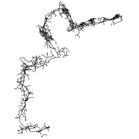
The walked line is cut from 26 OpenStreetMap relations, 39番札所~40番札所 through 64番札所~65番札所, in walking order. The Overpass query is pilgrimage-wide and returns all 89 四国遍路 relations; each section pins the slice of that result it walks, and a boundary relation belongs to the section that walks it — so Iyo begins at Temple 39, where Tosa's last relation ends, and ends at Temple 65, where Sanuki begins.
route.geojson holds all of those relations' member ways, 14,893 points and 636.6 km of them, including the spurs and side paths a walker does not follow. route.main.geojson is the shortest connected path through the same graph — 13,983 points, 365.7 km — and it is the line every stage, every stage distance and every waypoint position on this page is measured along.
Tradition
Primary faith: Shingon Buddhism
The circuit traces the path of the monk Kūkai (774–835), Kōbō Daishi, who founded Shingon Buddhism in Japan and practised asceticism across Shikoku before founding the monastic centre on Mount Kōya. The 88-temple circuit was formalised during the Edo period.
The pilgrimage maps a stage of spiritual progression onto each of Shikoku's four provinces, and the one this section's metadata.json records for Iyo is enlightenment.
Credential: the nōkyōchō (納経帳), a calligraphy book bought at Temple 1 and carried across all four dōjō. At each temple the monks write the temple name, its principal deity and its number, and apply three red stamps. A completed book earns the kechigan-shō, the completion certificate — which is awarded for the circuit, not for any one section of it.
Files & CDN
The complete dataset lives at routes/shikoku-88-iyo/:
| File | Contents |
|---|---|
metadata.json | Overview, tradition, logistics, and provenance — including the full day rule |
route.geojson | Every member way of the pinned relations — 14,893 points |
route.main.geojson | The walked line the stages are cut from — 13,983 points |
route.gpx | GPX 1.1 track for GPS apps and devices — 14,893 points |
stages.json | 14 day stages, with interior journey narratives |
waypoints.geojson | 953 waypoints — 26 curated temples, 927 from OpenStreetMap |
ways/route.json | The stage package's catalog card; ways/report.json beside it records what this section can and cannot promise a walker |
Available via jsDelivr CDN:
https://cdn.jsdelivr.net/gh/walktalkmeditate/open-pilgrimages@v1/routes/shikoku-88-iyo/metadata.json
https://cdn.jsdelivr.net/gh/walktalkmeditate/open-pilgrimages@v1/routes/shikoku-88-iyo/route.geojson
https://cdn.jsdelivr.net/gh/walktalkmeditate/open-pilgrimages@v1/routes/shikoku-88-iyo/route.gpx
https://cdn.jsdelivr.net/gh/walktalkmeditate/open-pilgrimages@v1/routes/shikoku-88-iyo/stages.json
https://cdn.jsdelivr.net/gh/walktalkmeditate/open-pilgrimages@v1/routes/shikoku-88-iyo/waypoints.geojson
Route ID: shikoku-88-iyo
Contains information from OpenStreetMap, which is made available under the ODbL by the OpenStreetMap Foundation. This includes the route geometry, the stage anchors, the waypoints, and the road network drawn behind the route at the top of this page.
© OpenStreetMap contributors, ODbL.